NVBA NEWS BLOG
Welcome to the blog for Northern Virginia Bird Alliance, a wealth of resources about northern Virginia birds, wildlife, habitat conservation and restoration, native plants, wildlife-friendly gardening, advocacy and more.
Birding is for Every Body: Birdability Week, October 20-26
Have you ever paused to think about how many people might want to join us in birding but can’t?
Photo: Birdwatching from a wheelchair, USFWS Headquarters, Public domain, via Wikimedia Commons
Jo Doumbia
Have you ever paused to think about how many people might want to join us in birding but can’t? Not because they lack interest, but because the trail is too rough for a wheelchair, the signage is too small for someone with limited vision, or the group atmosphere doesn’t feel welcoming to someone living with anxiety. That’s where Birdability comes in.
Founded by Virginia Rose, a birder and wheelchair user, Birdability is a nonprofit with a powerful vision: birding should be welcoming, inclusive, safe, and accessible for everybody and every body. Its mission goes far beyond removing barriers on trails. It’s about creating community, dignity, and joy for people of all abilities.
Birding is often seen as one of the most accessible hobbies: you can do it anywhere, at any age, with very little equipment. But in reality many opportunities are closed to people living with mobility challenges, sensory disabilities, chronic illness, or neurodivergence. That means a vast number of potential birders and future conservation allies are left out.
When we design programs with accessibility in mind, we don’t just help others: we strengthen our own community. Accessible trails and viewing platforms mean families can bird together. Clear communication and welcoming environments make first-time birders feel at home. Inclusion helps us live out the truth that birds belong to everyone.
Birdability offers tools to make this possible. Its crowdsourced Birdability Map, created by National Audubon Society in association with Birdability, helps birders of all abilities know what to expect at birding sites. Resource documents on Birdability’s website guide leaders on inclusive practices and respectful communication. And each October, Birdability Week shines a light on accessible birding with events, workshops, and celebrations across the country.
As birders, we can be part of this change. We can start by noticing where barriers exist, sharing reviews of our favorite spots, and experimenting with accessible outings. Most of all, we can open our doors wider and welcome people who may not have thought birding was for them.
Accessibility isn’t just a checklist: it’s a mindset. It’s choosing to see birding not as an exclusive hobby, but as a shared language of wonder and joy that everyone deserves to speak. By embracing Birdability’s vision, we can open the door to new members, new friends, and new advocates for the birds and habitats we cherish.
Let’s make sure birding is truly for everybody.
Birdability Week: Celebrating Accessible Birding. Join Us for a Special Bird Walk!
As part of our ongoing commitment to inclusivity and making birding accessible to everyone, the Northern Virginia Bird Alliance is excited to celebrate Birdability Week!
Photo: Part of the Five Beaks Birdathon team
Tina Dudley
As part of our ongoing commitment to inclusivity and making birding accessible to everyone, the Northern Virginia Bird Alliance is excited to celebrate Birdability Week! This week is dedicated to raising awareness about the importance of accessible birding experiences and ensuring that bird watching is a welcoming activity for all individuals, regardless of mobility challenges or disabilities.
Why Accessibility Matters
Birding should be an activity enjoyed by everyone, and accessibility is a key factor in making this happen. For many, enjoying nature and birdwatching can be difficult if trails and facilities are not designed with accessibility in mind. By promoting accessible birding, we not only open up opportunities for more people to experience the joy of birdwatching, but we also foster a more inclusive community that values everyone’s ability to connect with nature.
Part of the Five Beaks Birdathon team
Accessibility features like level trails, clear signage, and accessible restrooms make a significant difference in allowing people with different abilities to enjoy birding. These features ensure that nature experiences are enjoyable, stress-free, and available to all, enhancing the sense of community and belonging.
Accessibility improvements benefit not only individuals with disabilities but also the broader community. Features such as smooth, well-maintained paths, clear signage, and accessible restrooms enhance the overall usability of spaces for everyone, including those with temporary injuries, parents with strollers, and older adults who may have mobility challenges. Birding is an activity particularly popular with our seniors. By designing and maintaining accessible trails, we ensure that the joy of birding can remain a part of people's lives well into their later years, preserving their connection to nature and their sense of independence.
Join Us for the Birdability Bird Walk
To celebrate Birdability Week and highlight accessible birding opportunities, we invite you to join us for a special Birdability Bird Walk on Sunday, October 27th. Here are the details:
Time: 8:00 AM
Meeting Location: Great Marsh Trailhead, Mason Neck National Wildlife Refuge
Directions: Located on Gunston Road, the parking lot is on the right 1.25 miles past High Point Road (which leads to Mason Neck State Park). Look for the 25 mph Speed Limit sign just before the parking lot.
The Great Marsh Trail is an excellent example of an accessible trail, featuring a level and wide asphalt surface for about 0.85 miles, leading to a scenic overlook of the Great Marsh. The trail is wheelchair accessible, ensuring a comfortable birding experience for all participants. For more details on the trail, you can check the Birdability review on the Birdability Location Explorer by searching for "Great Marsh Trail."
We plan to return to the parking lot by 10:00 AM. After the walk, participants may want to tour the Visitor Center, look for birds on Belmont Bay from the concrete pad behind the Visitor Center, and take a short stroll on the Osprey Trail overlooking Belmont Bay at Mason Neck State Park. Accessible restrooms are available at the Visitor Center for your convenience.
The Friends of Mason Neck State Park are committed to improving accessibility in the park. You can learn more about their Accessibility Program here.
Why You Should Attend
This bird walk is a great opportunity for anyone who has a mobility restriction such as a wheelchair, a walker, or someone who would benefit from a more level walking surface, but all are welcome to attend!
It's also a chance to meet like-minded bird enthusiasts and engage with our community in celebrating Birdability Week. Whether you're a seasoned birder or new to the hobby, this event promises to be a rewarding experience.
For any questions or additional information, please feel free to reach out to us. Let’s make birding accessible and enjoyable for everyone!
Happy birding!
Birdability Week 2021 is October 18-24!
Birdability Week is a celebration of birders with disabilities and other health concerns, and an opportunity to share resources and ideas to help the birding community be accessible, inclusive and welcoming to everybody and every body!
Birdability Week is a celebration of birders with disabilities and other health concerns, and an opportunity to share resources and ideas to help the birding community be accessible, inclusive and welcoming to everybody and every body! Learn more about Birdability Week here, and see if your favorite birding spots have been surveyed for accessibility features using the Birdability map.
You can also read an article by ASNV volunteer Steve Tzakis, who wrote about his extensive experience surveying parks and trails for accessibility.
New App Brings Awareness of ADA Requirements to Trails
As we celebrate Birdability Week, October 18 – October 24, 2021, we would like to highlight Steve Tzikas, an energetic volunteer who has been mapping trails in Northern Virginia for their “Birdability.”
Photo: Stephen Tzikas
As we celebrate Birdability Week, October 18 – October 24, 2021, we would like to highlight Steve Tzikas, an energetic volunteer who has been mapping trails in Northern Virginia for their “Birdability.”
“The Birdability Map is a crowdsourced map which describes the accessibility features of birding locations all over the world. This allows people with accessibility challenges to find out in advance if a birding location is one they would like to visit.”
Read Steve’s account of his mapping experience:
In early 2021 I inquired if the Audubon Society of Northern Virginia needed any volunteers for a citizen science field project that involved exercise. As I got older I needed more exercise opportunities, but as a scientist and engineer, I wanted it to involve science to keep my interest. The response I received informed me about Birdability, which was founded in 2016 by Virginia Rose. As the Birdability website notes,
“Birdability works to ensure the birding community and the outdoors are welcoming, inclusive, safe and accessible for everybody.” They “focus on people with mobility challenges, blindness or low vision, chronic illness, intellectual or developmental disabilities, mental illness, and those who are neurodivergent, deaf or hard of hearing or who have other health concerns.”
A lot of information can already be found on the Internet about Birdability, including that found on its own website. Rather than repeat much which has already been noted by others, this article focuses on how a government regulation can become common knowledge to the public.
Accessibility is an important part of trail development, because it is key to ensuring that trails are available to all groups such as the elderly and people with disabilities. The first accessibility laws were enacted in 1968 under the Architectural Barriers Act (ABA) of 1968. The Americans with Disabilities Act (ADA) of 1990 prohibited discrimination based on disability.
After some thought the proposal to volunteer and evaluate trails for Birdability became an interesting prospect, even if not citizen science. Birdability still offered exercise by walking trails, but it also intrigued me. One of my many duties as an engineer over the years was the creation and review of facility design standards and agency policies as they related to specific requirements for the environment, safety, health, and security. These were technical requirements that few people, except professionals, ever see. Such regulations keep the public safe, even if they are not aware of their surroundings and the issues that impact them. Sometimes, during reviews, a rather broad-based standard could include many other requirements not necessarily for my attention, but for other professionals in collaborating offices. As such, I would see information pertaining to ADA requirements.
So, when I reviewed the Birdability template used in trail reviews, I thought about how this organization took a complicated regulation and converted it to an app for the public to use, educating them in the process. Moreover, this caught my interest, because as an engineer I also develop models that track government operations based on transactional data and the resource requirements that are part of those operations. Developing models based on big data is another item only professionals will do. But, Birdability developed a public app based on “dry” government requirements and made it appealing, useful, and educational.
The Birdability survey template covers the basic ADA requirements so people with accessibility challenges can access a reviewed trail quickly and get outside to experience the natural surroundings. When submitting a survey, reviewers are asked to comment on ADA aspects including parking, ramps, restrooms, and other accessible features as well as trail accessibility criteria such as surface(s), slope(s), shade, benches, gates, railings, steps, and viewing blinds.
The largest section is for any additional information. This connects the trail to the types of birds seen, seasonal conditions, width of trails, overall difficulty, wildlife activity, and so on. This is followed by a section for rating the location's overall accessibility, and there is the ability to add photographs.
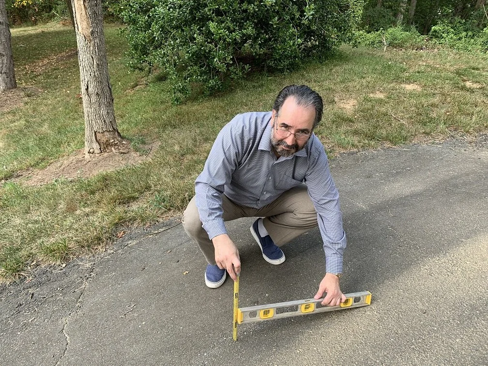
I forwarded suggestions for improvements, whether for future upgrades of the website itself, or to fellow reviewers on best practices for entering a review. For example; slope criteria are noted, but it’s not always an easy task to measure, especially if a trail has a lot of vertical variability. Reviewers can’t be expected to conduct an engineer’s transit measurement on every trail slope encountered. At first I attempted to measure the slope with the greatest incline. I used a simple astrolabe I owned to get a quick estimate for the degrees of inclination. However, it was even easier to take a photograph and post it so a reader could decide whether such inclines posed a challenge to their body strength or wheelchair. The photograph section of the survey template acted as a useful place to add information that words alone could not describe accurately. I also noted other ideas by including comments, such as whether a trail is accessible through public transportation.
Steve measuring slope
While most people might associate ADA with people using wheel chairs, the ADA also covers conditions due to deafness, blindness, diabetes, cancer, epilepsy, intellectual disabilities, missing limbs, autism, and other medical conditions.
The accessibility guidelines apply to those trails that are designed and constructed for pedestrian use. These guidelines are not applicable to trails primarily designed and constructed for recreational use by equestrians, mountain bicyclists, snowmobile users, or off-highway vehicle users. Regulations also recognize the existence of constraints and limitations in the outdoor environment and allow for certain other exceptions.
I do many of my reviews in my town of Reston, Virginia. Reston was founded in 1964 as a planned community. Today it has 60,000 residents, over 55 miles of walking paths, about 250 acres of woodlands and open space, 4 lakes, and a tree canopy covering about half of its total area. There is a high degree of accessibility, and there are many birds along the paths and lakes. Birdability offers the chance to get to know your community and what it has to offer. The Birdability map notes the locations where people have submitted reviews. It is constantly growing with submissions.
Steve with Astrolabe
If you are seeking a good experience with exercise and learning, Birdability mapping may be the one for you. Visit the website and view the Birdability map, where you can read what others wrote, as well as submit your own trail review. Whether it is a simple trail review, or a more thoughtful one that attempts to identify the variety of birds and their habits through the seasons, it’s worth a try.
Let’s Put Northern Virginia on the Map...The Birdability Map!
“Birding is for everybody, and every body!” This is the motto of Birdability, a growing global effort that works to decrease barriers for birders with mobility, vision, developmental, hearing, and other health challenges.
Annaliese Meistrich, ASNV intern
“Birding is for everybody, and every body!” This is the motto of Birdability, a growing global effort that works to decrease barriers for birders with mobility, vision, developmental, hearing, and other health challenges. The organization, and the movement it inspired, hope to eliminate many of the accessibility challenges that these birders face on a regular basis in order to share the joys of birding with them. The founder, Virginia Rose, a board member of Travis Audubon in Texas, had fallen at a young age and now uses a wheelchair. She found a passion in nature and birding which became the inspiration behind Birdability. A key effort is to have birders and others contribute birding locations to the Birdability Map, “a crowd-sourced map of accessible birding locations, with details of the accessibility features of them.” Their website has a wealth of resources on birding with accessibility challenges, and how individuals and organizations alike can ensure they are welcoming and inclusive. ASNV has a team of board members and adult and youth volunteers who have to date added 43 trails to the map.
The beauty behind this movement is that anyone can contribute! All it takes is a few minutes of your time while you are on a bird outing. By completing and posting responses to a simple survey, you can submit accessibility reports and help put Northern Virginia on the map. All information you need on assessing a trail can be found here.
As you prepare to review a trail, here are a few things to keep in mind. First, check the Birdability Map itself, to ensure that the trail you wish to review has not just been assessed. It can be helpful to have a printed version of the survey questions while out on the trail. (A concise, printable checklist will be added soon to the website.) You might want to complete and submit the survey later from notes, when Internet access may be more certain. In addition, a tape measure has proven to be extremely useful for accurately measuring railing heights, door entry widths, etc.
Here are a few things to record about general accessibility, if able.
First, public transit access. Are there additional methods of transportation (bus, metro) besides an automobile to this site?
Is the trail particularly wet or muddy most of the time, during high tide, or after a storm?
Any breaks in an otherwise accessible trail?
It is important to note any park issues such as car break-ins, vandalism, or any other notable information.
Lastly, if you know how to do this, copy and paste the eBird link for the site or note interesting birds that can be seen there. That way people will know what birds to look for and the general area the birds might be in.
There are a few specific tips that will prevent confusion. For example,
when placing the pin drop, ensure that you manually place the pin on the trail head. If you use the address alone, the pin drop does not necessarily mark the actual start of the trail. This can cause the report to be misplaced on the Birdability Map.
If you post trail segments for one trail--a common practice when trails are not completely accessible in all sections--accurately placing different pin drops and naming the trail segments distinctly is especially important for separating the reports on the map.
Last is the issue of measuring slopes. The survey requests information regarding the steepness of slopes. Sometimes this information is available on signs at trailheads. Other times your guess is the best you can do! There are comment boxes for every survey question so you can note the fact that this observation was your best approximation.
If you would like to determine the slope grade, free smartphone apps like Bubble Level for iPhone can help with this process. To calculate the slope yourself, measure--or at least estimate--the length of the slope and then, from the bottom of the slope, measure from the ground up to where the measuring tape is level with the top of the slope. (See illustration below.)
With this information, you can now find the slope grade by dividing the slope height into the length of the slope in inches. For instance, the grade of a 20-foot slope with a 30-inch rise is (20 x 12 inches) divided by 30 is 8:1.
You can also post photos of slopes, obstacles, or other sights of interest to this birding location so readers can assess the trail based on their own capacities. In addition to this, you can pin any notable access points on the trail such as observation platforms, bird blinds, car birding platforms or anywhere else that one may be able to bird from.
If you would like more information, there are many resources at birdability.org. If you have mapping questions, please do not hesitate to contact us at info@audubonva.org.
Thank you for joining us in supporting the Birdability movement and happy trails to everyone!